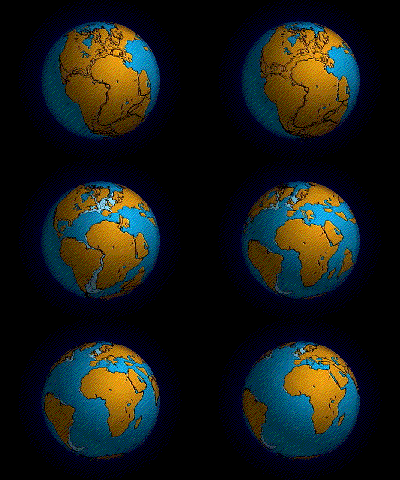
Continental drift is the movement of the Earth's continents relative to each other. The hypothesis that continents 'drift' was first put forward by Abraham Ortelius in 1596 and was fully developed by Alfred Wegener in 1912 when he noticed that the shapes of continents on either side of the Atlantic Ocean seem to fit together (for example, Africa and South America). Francis Bacon, Antonio Snider-Pellegrini, Benjamin Franklin, and others had noted much the same thing earlier. However, it was not until the development of the theory of plate tectonics in the 1960s, that a sufficient geological explanation of that movement was found.
The similarity of southern continent fossil faunas and some geological formations had led a relatively small number of Southern hemisphere geologists to conjecture as early as 1900 that all the continents had once been joined into a supercontinent known as Pangaea.
The concept was initially ridiculed by most geologists, who felt that an explanation of how a continent drifted was a prerequisite and that the lack of one made the idea of drifting continents wholly unreasonable.
The theory received support through the controversial years from South African geologist Alexander Du Toit as well as from Arthur Holmes. The idea of continental drift did not become widely accepted as theory until the 1950s in Europe.
By the 1960s, geological research conducted by Robert Dietz, Bruce Heezen, and Harry Hess along with a rekindling of the theory including a mechanism by J. Tuzo Wilson led to acceptance among North American geologists.
The hypothesis of continental drift became part of the larger theory of plate tectonics. This article deals mainly with the historical development of the continental drift hypothesis before 1950.
Another illustrative example is the discovery of fossils of the aquatic reptile Lystrosaurus from rocks of the same age from locations in South America, Africa, and Antarctica. There is also living evidence - the same animals being found on two continents. An example of this is a particular earthworm found in South America and South Africa.
The complementary shapes of the facing sides of South America and Africa is obvious, but is a temporary coincidence. In millions of years, seafloor spreading, continental drift, and other forces of tectonophysics will further separate and rotate those two continents. It was this temporary feature which inspired Alfred Wegener to study what he defined as continental drift.
Continental Drift Hypothesis Wikipedia
Development of Tectonophysics
He was an outsider with a doctorate in astronomy attacking a established theory between geophysicists. The geophysicists were right to state that the Earth is solid, and the mantle is elastic (for seismic waves) and inhomogeneous, and the ocean floor would not allow the movement of the continents.
But excluding one alternative, substantiates the opposite alternative: passive continents and an active seafloor spreading and subduction, with accretion belts on the edges of the continents. The velocity of the sliding continents, was allowed in the uncertainty of the fixed continent model and seafloor subduction and upwelling with phase change allows for inhomogeneity.
The problem too, was the specialization. A. Holmes and A. Rittmann saw it right (Rittmann 1939). Only an outsider can have the overview, only an outsider sees the forest, not only the trees (Hellman 1998b, p. 145). But A. Wegener did not have the specialization to correctly weight the quality of the geophysical data and the paleontologic data, and its conclusions. Wegener's main interest was meteorology, and he wanted to join the Denmark-Greenland expedition scheduled for mid 1912. So he hurried up to present his Continental Drift hypothesis.
Timeline of the Development of Tectonophysics Wikipedia
The Great Rift Valley

The name continues in some usages, although it is today considered geologically imprecise as it combines features that are today regarded as separate, although related, rift and fault systems.
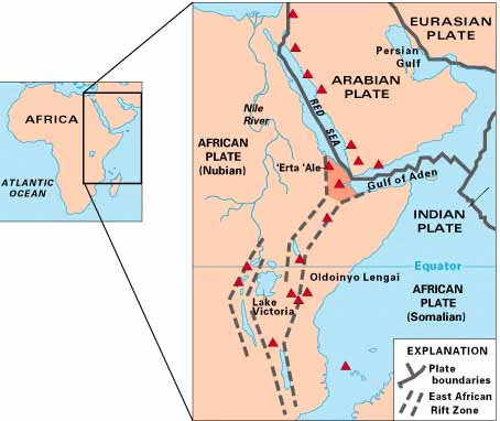
Today, the term is most often used to refer to the valley of the East African Rift, the divergent plate boundary which extends from the Afar Triple Junction southward across eastern Africa, and is in the process of splitting the African Plate into two new separate plates. Geologists generally refer to these incipient plates as the Nubian Plate and the Somali Plate.
The Great Rift Valley Wikipedia
In the News
Texas and Antarctica Were Attached, Rocks Hint National Geographic - August 17, 2011
About 1.1 billion years ago, what are now El Paso, Texas, and Antarctica appear to have existed side by side, scientists say. The find is part of a decades-long effort to piece together fragments of an ancient supercontinent that existed before Pangaea. "Most people are familiar with Pangaea," said study co-author Staci Loewy, a geochemist at California State University, Bakersfield. "That was a supercontinent that formed 300 million years ago." Pangaea began to break apart about 225 million years ago due to geological processes related to plate tectonics, which eventually spread Earth's landmasses into the continents we see today. The supercontinent's pieces can be reassembled by tracing ancient mountain belts and other geologic patterns - such as the Appalachian Mountains, which are geologically related to mountains of England and Scandinavia.
Red Sea Region Parting in Massive Split National Geographic - July 19, 2006
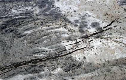
Moses may have received some geological assistance when he parted the Red Sea to let the Israelites through, according to the Bible. In a new study, scientists have determined that a recent tear in Earth's continental crust near the sea is the largest single rip seen since satellite monitoring began.
Secrets of ocean birth laid bare BBC - July 20, 2006
The largest tear in the Earth's crust seen in decades, if not centuries, could carve out a new ocean in Africa, according to satellite data. Geologists say a crack that opened up last year may eventually reach the Red Sea, isolating much of Ethiopia and Eritrea from the rest of Africa. The 60km-long rift was initially sparked by an earthquake in September. Follow-up observations reported in the journal Nature suggest the split is growing at an unprecedented rate.
Satellite Captures Creation of New Continental Crust Scientific American - July 20, 2006
A new sea is forming in the desert of northeastern Ethiopia. Millions of years from now, the pulling apart of the Arabian and Nubian tectonic plates will allow waters to rush in and widen the Red Sea.
Scientists: Earthquakes causing Red Sea to part MSNBC - July 19, 2006

Arabian tectonic plate and African plate are moving away from each other
Exodus From Drying Sahara Gave Rise to Pharaohs, Study Says National Geographic - July 20, 2006
Sahara Desert Was Once Lush and Populated -- The pharaohs of ancient Egypt owed their existence to prehistoric climate change in the eastern Sahara, according to an exhaustive study of archaeological data that bolsters this theory. Starting at about 8500 B.C., researchers say, broad swaths of what are now Egypt, Chad, Libya, and Sudan experienced a "sudden onset of humid conditions."
How Did Continents Split? Geology Study Shows New Picture PhysOrg - May 24, 2006
Like pieces in a giant jigsaw puzzle, continents have split, drifted and merged again many times throughout Earth's history, but geologists haven't understood the mechanism behind the moves. A new study now offers evidence that continents sometimes break along preexisting lines of weakness created when small chunks of land attach to a larger continent.


0 komentar:
Post a Comment